


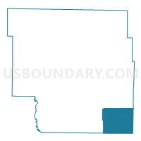
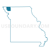
Washington Voting District, Nodaway County, Missouri
About
Outline

Summary
| Unique Area Identifier | 609257 |
| Name | Washington Voting District |
| County | Nodaway County |
| State | Missouri |
| Area (square miles) | 47.32 |
| Land Area (square miles) | 47.31 |
| Water Area (square miles) | 0.01 |
| % of Land Area | 99.97 |
| % of Water Area | 0.03 |
| Latitude of the Internal Point | 40.17549250 |
| Longtitude of the Internal Point | -94.68080530 |
Maps

Graphs
Select a template below for downloading or customizing gragh for Washington Voting District, Nodaway County, Missouri


Neighbors
Neighoring Voting District (by Name) Neighboring Voting District on the Map
- Cooper West Voting District, Gentry County, MO
- Grant Voting District, Nodaway County, MO
- Jackson West Voting District, Gentry County, MO
- Jefferson Voting District, Nodaway County, MO
- Platte East Voting District, Andrew County, MO
- Platte West Voting District, Andrew County, MO
Top 10 Neighboring County Subdivision (by Population) Neighboring County Subdivision on the Map
- Cooper township, Gentry County, MO (1,859)
- Jackson township, Gentry County, MO (1,425)
- Jefferson township, Nodaway County, MO (836)
- Grant township, Nodaway County, MO (560)
- Platte township, Andrew County, MO (426)
- Washington township, Nodaway County, MO (358)
Top 10 Neighboring Place (by Population) Neighboring Place on the Map
Top 10 Neighboring Unified School District (by Population) Neighboring Unified School District on the Map
- Gentry County R-II School District, MO (2,293)
- North Andrew County R-VI School District, MO (1,898)
- King City R-I School District, MO (1,874)
- South Nodaway County R-IV School District, MO (997)
- Jefferson C-123 School District, MO (884)
Top 10 Neighboring State Legislative District Lower Chamber (by Population) Neighboring State Legislative District Lower Chamber on the Map
- State House District 28, MO (38,291)
- State House District 5, MO (38,074)
- State House District 4, MO (35,512)
Top 10 Neighboring State Legislative District Upper Chamber (by Population) Neighboring State Legislative District Upper Chamber on the Map
Top 10 Neighboring 111th Congressional District (by Population) Neighboring 111th Congressional District on the Map
Top 10 Neighboring Census Tract (by Population) Neighboring Census Tract on the Map
- Census Tract 4705, Nodaway County, MO (5,474)
- Census Tract 9602, Gentry County, MO (3,746)
- Census Tract 104, Andrew County, MO (3,051)